Travelogue – Leh Ladakh
The best part about having a blog is that you can share your experiences with a wider audience. I have been missing in action for two weeks now and needed to put some thing up fast. The easiest was to put up my Leh-Ladakh experiences.
For a bit of Background -the state of Jammu and Kashmir consists of three divisions – Jammu, Kashmir Valley and Ladakh. Ladakh has two districts – Leh, the capital city and Kargil, where the armed conflict between India and Pakistan took place in 1999 (July, 2009 marked the 10 years of the Kargil war).
The word ‘la’ in Ladakh language means mountain pass, Ladakh there fore means Land of the high passes. Ladakh lives by its name and you have to cross some of the highest passes, Khardung la, Zoji La, Chang la, Taglang la while you travel in and around Ladakh.
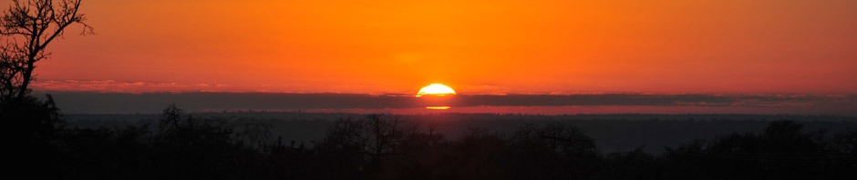
My friend, Prateek and I took the morning flight to Leh on 17th July 2009. The flight lands in Leh at around seven in the morning (Indian Standard Time). You can take nice snaps from the aeroplane window. Try to sit in the first few seats from the front so that the wings do not disturb your view. Also try to sit on the left side because in the morning flights the sun is very bright on the right side of the flight and will brighten the snaps too much. The view is really riveting as you fly over the Himalayan, Ladakh and the Zanskar range of mountains. You can also see waters streams emanating from the molten glaciers and snow covered mountain tops.
Day 1-2- Monastery Visit
If you flying to Leh, its better you take the first day off for acclimatization. You do well dizzy and a bit disoriented. But by the second day, you are typically acclimatised.
Leh with an area of 45110 Sq Km makes it largest district in the country in terms of area. The district is bounded by Pakistan occupied Kashmir in the West and China in the north and eastern part and Lahul Spiti of Himachal Pradesh in South East.
We stayed in Hotel Bijoo. Run by four brother, Hotel Bijoo, http://www.bijooladakh.com is a comfortable place of residence in Leh. We became particularly friendly with the eldest brother Ashik Bhai, who takes care of the day to day management of the Hotel. He also managed our itinerary to and from Leh.
The first thing that strikes you in Leh is the few number of Indian travellers and the large number of European (mostly French and German) and Israeli travellers. Whether it’s trekking, biking or cycling expedition, Ashik Bhai arranges every thing for his guests. Like other good travel operators he has tie ups with lots of travel companies abroad.
The first day we visited the monasteries of Hemis, Thiksey and Shey all located within a radius of 40 Km from Leh. Hemis is the post popular of the monasteries. It was established in 1672 AD by King Senge Nampar Gyalva. Hemis is best known to tourists for the colourful festival held in June-July, where monks perform their traditional dances.

At Thiksey Monastery, again an outstanding specimen of Ladakhi architecture, we sat as the monks performed the daily prayer ritual. The monasteries in Ladakh enhance the beautiful landscape of Ladakh. All are situation at an elevation with beautiful brown doors and windows, white wall with brown borders.

Shey is a town in Ladakh that has the old summer Palace of the kings of Ladakh. It is located 15 km from Leh towards Hemis. The palace was built more than 555 years ago by Lhachen Palgyigon, the king of Ladakh. The old palace Gompa has the largest golden Buddha statue in Ladakh.

On our way back we stopped by the river Indus. The river is popularly known as Sindhu. We relaxed around the banks of the river. If you come in the month of June, you can be a part of the Sindhu Darshan Festival. It is celebrated on the full moon day (Guru Poornima) in the month of June. It stretches on for three days.
“A large number of participants from different parts of the country participate in Sindhu Darshan Festival. They bring water from the river of their own state in earthen pots and immerse these pots in the Sindhu River. Consequently, the waters of all rivers mingle together, thereby symbolizing the multi-dimensional cultural identity of the country. The first day of the Sindhu Darshan Festival witnesses a reception ceremony for the participants, organized on the banks of Sindhu at Shey. This reception ceremony is conducted by a joint association of Ladakh Buddhist Association, Shia Majlis, Sunni Anjuman, Christian Moravian Church, Hindu Trust and Sikh Gurudwara Prabhandak Committee. As a part of the ritual, fifty senior Lamas conduct a prayer on the banks of the river. A series of cultural programs is also presented by the artists from various states of the country. A sightseeing tour is organized for the participants and the day comes to an end with a bonfire at night. After the cultural programs and sightseeing trip, a puja is organized on the second day of the Sindhu Darshan Festival. On the third day, the participants get ready for the departure- http://www.indobase.com/events/details/sindhu-darshan-festival.php “.
The first two days we also ambled in the market place. We did not buy any thing except a few maps. There is a State bank of India ATM in case you need cash. There is a German Bakery which is very popular with the Europeans.
Day 3 – Pangong Tso (Tso is the local word for Lake)
The next day we started early (around seven in the morning) for Pangong.
Pangong Tso is geographically situated in a disputed territory, claimed both by India and China. On October 20, 1962, Pangong Tso saw military action during the Sino-Indian War. Pangong Tso is still a delicate border point along the Line of Actual Control. <Wikipedia for more details>
The brackish water of the lake is devoid of any micro-vegetation.
")
To reach Pangong Tso we had to cross third-highest pass in the world, the Changla pass standing at 17350 feet above see level. (Well I want to mention here that the ranking that I will use for the passes here is as per the common knowledge). The army has a base here and they serve tea for travellers. It was a very sweet gesture. Changla pass was also our first tryst with ice. After clicking a few snaps we started our descent. We got a little delayed because the roads were being repaired by the Border Road organisation (BRO). BRO does a phenomenal job, with most of the border roads better maintained than the roads in other parts of the country.
“It rains less in Ladakh than it does in the Sahara desert” and “Ladakh is in the ‘rain shadow’ of the Himalayas” are both common descriptions of the weather in Ladakh.

Average yearly rainfall in this high altitude desert is from 3 to 6 inches (8 to 15 cm). For that reason all crops are irrigated through an intricate network of canals fed by springs and glacial melt. I cannot say whether it rains less than Sahara or not, but during our stay there was a minor drizzle and once a heavy rain accompanied by snow fall (my first experience with snow fall) in one of the mountain passes. I can say only that much that it’s in the interest of people that it does not rain much there because the woes overrun the benefit.
The spectacular lakeside is open during the tourist season, from May to September.
Though we made a day trip to the lake, there is also arrangement for a night say at Pangong Tso.
Day 4-5 Tso- Moriri
Tso Moriri or Lake Moriri (official name: Tso Moriri Wetland Conservation Reserve), is one of the highest lake in the world, with an altitude of 4,595 m (15,080 ft). Accessibility to the lake is limited to summer season only.
We were supposed to spend the night in a camp in Tso Moriri. The drive from Leh to Tso Moriri is one of the best drives we have had. We drive by the Indus River for more than a hundred km. We cross the Indus at the Mahe Bridge. Parts of the approach road from here are not metallic. I would say the visit to Tso Moriri is an ideal for wind life and nature enthusiasts. You will find lots of hot springs, sulphur laden wasteland, lots of migratory birds and the Himalayan Marmot. In fact Tso Moriri and Tsokar wetlands (not too far from Tso Moriri) represent the only breeding ground of the bar-headed goose and the threatened black-necked crane.
We stayed at the ‘Nomadic Camp ‘run by a Ladakhi -Dorji. This was the first camping experience and sound of the winds hitting the tent walls is quite enthralling.

Well any mention of Tsomoriri is incomplete without the mention of the nomads. “Changpas”, the nomadic shepherds (pastoral community) of yak, sheep, goat, and horses of Tibetan origin are the main inhabitants of the area. Changpa herders use the land of this valley as grazing ground and for cultivation. On the way you will find lots of circular stone enclosures which are used by nomads to keep the cattle. The steady increase in the livestock population in the area is mainly attributed to influx of nomadic herders from Tibet during recent decades.

We reached Tsomoriri through one way and left through the other. We came along the Indus River and on our way we took the Manali – Leh highway. Before the highway there is the Tsokar Lake. Tsokar means salty lake in local language and salt was extracted from this lake in earlier times, till the end of 1959, for consumption by the local people. You can also see the wild ass around the same area. We were not lucky as it was cloudy and hence missed a lot of migratory birds and the wild ass. On the way back we had to cross the Taglang la pass and it was the first time we experienced snow fall. The pass is at 17000 ft and the rain condensed into ice. Fresh snow on the mountain tops was one of the life time experiences.
Day 6-7 Nubra Valley
Nubra Valley is about 150 km north of Leh. Local scholars say that its original name was Ldumra (the valley of flowers). The Shyok River meets the Nubra or Siachan River to form a large valley that separates the Ladakh and the Karakoram Ranges. The average altitude of the valley is about 10,000 ft. above the sea level.
The way to Nubra Valley is through the world’s highest motorable road, Khardongla Pass which is at a hight of 18380 ft above sea level and around 50 kms from Leh.

Like the rest of Ladakh, Nubra is a high altitude desert with rare precipitation and scant vegetation except along river beds. Siachen Glacier lies to the north of the valley. The Sasser Pass and the famous Karakoram Pass lie to the northwest of the valley and connect Nubra with Xingjian. Previously there was much trade passing through the area with East Turkestan and Central Asia and explains the presence of Bactrian Camels.

The Nubra Valley has a historical romance, for the much famed Silk Route meandered along the banks of Nubra. From Xinjiang provinces of China via the mighty Karakoram Pass and Daulat Beg Oldi, travelers, traders, romantics, camels and horses travelled up and down in this valley reaching Leh before starting another long journey to Central Asia via Skardu and Gilgit. The graves of Yarkandi merchants of yore that one could see even today in Hunder, a village on the banks of Nubra, is a living testimony of this past journey. http://www.travelwebdir.com/travelarticles/The-Nubra-Valley-1939.html
On the Shyok (pronounced Shayok) River, the main village, Diskit, is home to the dramatically positioned Diskit Gompa- monastry. We visited the beautiful monastery.
Not too far from Diskit, for a few kilometres, you will find the sand dunes. You can take a camel ride at Rs 150.

At Nubra we stayed overight at an Organic Camp. Run by a Ladakhi it is a beautiful camp. The camp grows its own wheat, mustard for oil, and a variety of fruits and nuts, including apple, walnut and apricot.

On the way back from Nubra, we stopped at Shanti Stupa in Leh. The Stupa was constructed by a Japanese Buddhist organization, known as ‘The Japanese for World Peace’. The aim behind the construction of the stupa was to commemorate 2500 years of Buddhism and to promote World Peace. His Holiness, the Dalai Lama inaugurated the Shanti Stupa in the year 1985.

Sitting at the open portico of the stupa and overlooking the city of Leh was one of the most peaceful experiences.
Day 8- Kargil
We left for Kargil via Pattharsahib Gurudwara.
The history of Gurudwara is really interesting . Built by Buddhist Lamas nearly five centuries ago to commemorate the visit of Guru Nanak, the founder of the Sikh religion, to Ladakh, the Gurudwara Pathar Sahib is visited by Hindu and Sikh devotees, besides tourists.
Although the Ladakh’s culture and religion is deeply influenced by Buddhism, the existence of Gurudwara ‘Pathar Sahib’ adds to the region’s religious history and identity.
Legend has it that many centuries ago a demon had terrorised the people of Leh.
Baba Guru Nanak, who visited the region around 1516 A.D, came to know about the problem and decided to bless them with his sermons.
Locals welcomed him with open arms. His growing popularity angered the demon and in a fit of rage, he decided to kill Guru Nanak with a large boulder.
The boulder, however, turned into wax as soon as it touched Guru Nanak.
“Thinking the Sikh Guru must have got killed by the boulder; the demon appeared only to be shocked to find Guru Nanak Dev meditating. He pushed the boulder with his right foot, but as it had already melted into wax, his foot got embedded in it. Realising, Guru’s enormous powers, the demon fell at his feet and sought forgiveness.
Since then, resident Lamas revere the boulder and offer prayers to it.
In 1948, the Gurudwara Pathar Sahib’s maintenance was taken over by the Army.
The region has a sizeable Sikh population and devotees visit the site to have their wishes fulfilled.
On the way to Kargil you will see the confluence of Sindhu and Zanskar Rivers, Moon land, (a section of the mountain which has an uneven surface which resembles the uneven surface of the moon). We missed the Alchi Monastry and the Lamayuru Monastery.
The next important stop was at Mulbek. We had to cross two high altitude passes before we reached Mulbek; viz., Fotu La and Namika La. Fotu La @ 13,479ft is the highest point on the Srinagar – Leh road.

Mulbek is a historical site which houses one of the five Bamiyan Style of Buddhas located in Ladakh. The Buddha statue about 30 ft in height is an imposing statue which is carved across a vertical rock-face standing independently. This sculpture suggests that the early Buddhist movement along the Silk Road in the 3rd to 5th cent AD passed throug Ladakh and presumably the Karakorum Pass to the Taklamakan Basin (Southern Silk Road).
From Mulbek we proceeded on towards Kargil the place where the historic Kargil war.
We reached Kargil at around four in the evening.
Kargil with a population of 1.25 lakhs is scattered over an area of 14,086 Sq. Km. The name Kargil is derived from two words Khar and rKil. Khar means castle and rKil means center thus a place between castles as the place lay between many kingdoms. In the views of many critics, the word Kargil has been derived from the words Gar and Khil. Gar in local language mean ‘Any where’ and Khil means a central place where people could stay. This has the support of the fact that the place is equidistant from Srinagar, Skardo, Leh and Padum with around 200 Kms. With the passage of time Khar rKil or Gar Khil came to be known as Kargil. The present bureaucrat and historian Parvez Dewan in his contribution to the book “Kargil Blunder” reveals that a pioneer namely Kargeel cleared the forests in Poyen and Shilikchay area before the advent of Thatha Khan to dwell in the area and later the place assumed its name. Kargil is mostly inhabited by Shia Muslims and Agas are the religious head and preachers.

Kargil became a separate district in the Ladakh region during the year 1979 when it was bifurcated from the erstwhile Leh district.
Day 9
We left for Srinagar very early at around five in the morning. The first stop was at Vijay Smarak (war memorial of Drass-Kargil). When we reached the preparations were in full swing to celebrate the ten years of Kargil war.
The main pass between Srinagar and Kargil is blocked by snow from November to May. Srinagar to Kargil road goes via Sonmarg, Zo-Zila pass, and Drass and normally it takes almost the whole day.
After the memorial, we stopped at Drass for some breakfast. A small township located in the heart of the valley bearing the same name, Drass experiences extremely cold weather in winters. Recurring snowfalls during winters lower the temperature of this township to as low as minus 40 degrees. Zojila pass, the Himalayan Gateway to Ladakh, serves as the starting point of the Drass valley of Kashmir.
Drass is the second coldest inhabited place in the world, and do not forget to take a glimpse of the famous Tiger Hill, the battle of which turned the tide of the Kargil War in favor of India, Kargil has a lot more to offer.
We reached Srinagar around noon. Srinagar (1,730m) is famous for its canals, houseboats and Mughal gardens. The city has long been a centre of the arts and learning. ‘Sri’ means beauty or wealth of knowledge and ‘Nagar’ means city. The city was originally founded by the great Buddhist emperor Ashoka – his old city is marked by the present village of Pandrethan. The present city was founded by Pravarasena II (79-139 AD) who named it “Praparapura” and built it practically contiguous with the old capital, which was called “Srinagari”.

Praparapura is recorded in Chinese annals by Hiuan Tsang who visited the city in about 630 AD and described it as extending about 4-km from north to south and about 2-km from east to west along the right bank of the Jhelum. King Ananta was the first to transfer his royal residence to the left bank of the river.
We stayed at a Houseboat on the Nageen Lake. Srinagar is a unique city because of its lakes – the Dal, Nagin and Anchar. The River Jhelum also flows through a part of the city.

Life on the lakes, as witnessed from the confines of a Shikara, is unique. We booked a Shikara which took us from Nageen lake to Dal Lake. We visited the Mogul Garden and the Shalimar Bagh. The large Maple trees in the Mogul garden allure every traveller to come and rest under its shade.
We missed the visit to the Shankarya Temple and the other important monuments in the city.
Day 10 – Home coming
I come to the end of the journey. I need to acknowledge Saurabh Upadhya of www.junglelore.net who arranged everything from Mumbai.
Fact Sheets
When to visit ladakh – June- September
How to reach lakadh – Flight to Leh (Jet and Kingfisher Red ) or Road Via Manali or Srinagar ( Motorable roads from Srinagar to Leh and from Manali to Leh )
Prithwish
<iframe src=”http://www.blogadda.com/rate.php?blgid=11276” width=”170″ height=”75″ frameborder=”0″ scrolling=”no” ></iframe>

prithwish
you have ventured out where some of us dream of and most of us are not even considering to travel to. the descriptions are awesone. please do add as to how much is the travel time from one place to the other and what mode of transportation are the options on each leg…. so, which stretches was walking and which ones in a car, or pony etc…. did not get a sense of that. thats about the only thing missing frankly. would love to see more snaps when i see you sometime. cheers, Sachin khandelwal
Yes Sir. I will update the Mode of conveyance. Also will add more details on Biking, Trekking and clycling opportunities.
Hey Prithwish,
This is a well written travel passage. Looks like you’ve had a lot of fun. Pangong Tso (lake) looks wonderful. Will surely get in touch with you, when I plan my trip to Leh and Ladakh.
Cheers
Niraj
Great travelogue. Its literally from the lows (plains) to the Highs (Ladhak, Srinagar) and back again to the lows.
Metaphorically speaking all the lows and highs were awesome. Had you not posted the pics, we would not have experienced the highs.
I want to see the array of pics you shot there. Your SLR is clicking fine. The play of light is amazing. I love the picture of the local walking away from camera.
Krishna
Mr. Mukherjee,
You are on your way to become a travel-writer in the league of William Dalrymple…..a riveting description and absolutely brilliant snaps.
But what I missed was your take on the life of people there, their culture, beliefs etc etc !!!
Amit
Very very detailed write up, equally inspiring as well, will surely catch hold of u if i ever plan to venture out, lovely pics too!!
Hi,
i have always wanted to travel to Ladakh but have never been able to take time out. Really liked the pictures (and the write-up too!). Envy you!!
Liked your motto… live before you philosophize… very true.. the latin phrase ( is it latin ?) is a bit difficult to remember…
Merci! And yes, it is latin.